Great Wass Island is one of Washington County’s jewels. The Nature Conservancy snapped up much of this ecological treasure in 1978. The peninsula stretches farther into the Atlantic than any other extension of the downeast mainland, at a point where the Bay of Fundy and Gulf of Maine waters meet. Thus it is virtually surrounded by the tempering effects of both, a mixture of moderate temperatures and constant humidity. Flora more common to Atlantic Canada reach the southern limit of their ranges here, and some of Maine’s rarest plants call the island home. The bogs (or heaths) on Great Wass are of a raised type that flourishes only in the most extreme maritime environments. Depressions left behind by glaciers 10,000 to 12,000 years ago slowly filled with accumulating layers of sphagnum moss, creating an acidic bog habitat supportive of carnivorous plants and stunted shrubs.
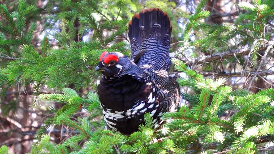
The preserve is home to many of Maine's northern forest species: palm warblers, boreal chickadees, spruce grouse, yellow-bellied flycatchers, and Lincoln's sparrows. Most of Maine’s coniferous–loving woodland warblers are present, such as Blackburnian, Canada, bay-breasted, and blackpoll. In the deciduous woods along the road and in the parking lot, all of the hardwood-loving warblers are findable – especially black-throated green, northern parula, and American redstart.
Common loons, common eiders and all three scoters (in winter) cover the waters close to shore. Bald eagles, ospreys and common ravens are nesters on Great Wass and its neighboring islands. In any season, harbor seals haul out in great numbers off Cape Cove.
One trail exits the parking lot, diverging into two: the Mud Hole Trail and the Little Cape Point Trail 100 yards later. The left fork (Mud Hole) meanders through spruce and fir for 1.5 miles until it reaches a narrow cove. From here it winds east until reaching Mud Hole Point. The views of Eastern Bay and its islands are panoramic. The right fork (Little Cape Point) wanders 2 miles through a jack pine, spruce, and fir forest carpeted in thick moss. After about a mile, open ledges offer a glimpse of the preserve’s best bog areas. Still further, a bridge presents the opportunity to walk through the bog area and evaluate its unique vegetation more closely.
Although either trail offers good birding, the Little Cape Point Trail is preferred for its length and a little more habitat variation. It is possible to do both trails as a loop. A cairn and a red marker indicate the shoreline terminus for each trail. Simply walk the shoreline between them for a loop of about 5 miles. It is also possible to hike the shoreline the full 4.5 miles from Little Cape Cove south to Red Head, but you must return the way you came because from there the shoreline is private property.
Directions: From Jonesport, cross the bridge to Beals Island, then continue over the causeway onto Great Wass Island next to Alley Bay. Continue straight ahead, following the hardscrabble road as it turns to dirt and narrows. About three miles from Beals, look for The Nature Conservancy parking lot on the left.
GPS: 44.481083, -67.594671